Hurricanes in Florida
When is Hurricane Season in Florida?
The official hurricane season in Florida follows the Atlantic hurricane season, starting on June 1 and concluding on November 30. Florida has experienced the brunt of hurricanes compared to other US states, with a record of over 120 direct hits since 1851.

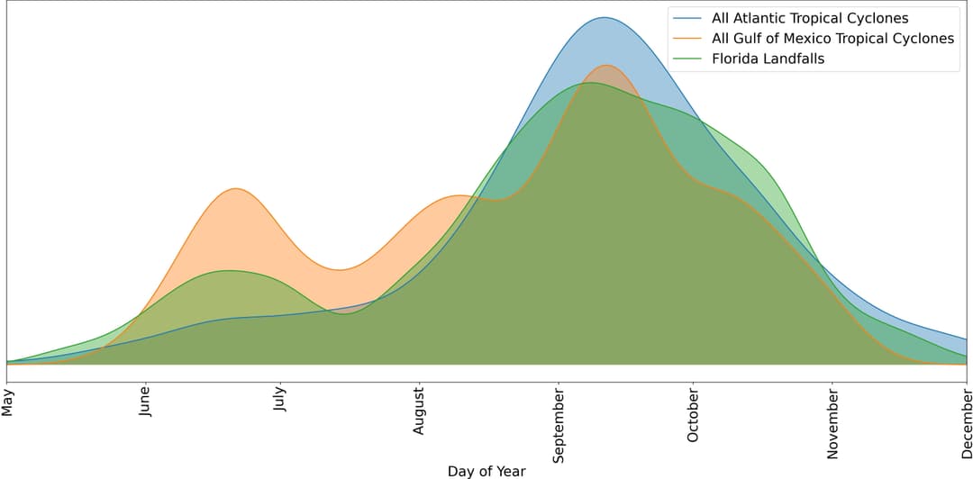
A detailed analysis of historical storm data reveals interesting patterns. The data, obtained from the NOAA National Hurricane Center's Hurricane Research Division, was represented in a graph above[1], demonstrating the likelihood of experiencing a hurricane on any given day of the year. We applied Gaussian smoothing to this historical storm data to better highlight the trends.
The graph compares daily probabilities of hurricanes from the Atlantic basin, Gulf storms, and actual landfalls of tropical storms in Florida. The peak of hurricane likelihood occurs in September, but there is a noticeable spike in tropical storm activity around June, which is characteristic of storms originating from the Gulf of Mexico. This proximity to the Gulf can also lead to an occasional risk of hurricanes outside the official hurricane season months.
The Gulf of Mexico is known to occasionally produce early storms due to its warm waters and favorable environmental conditions.
Where do Hurricanes Hit the Most in Florida?
The Atlantic Coast, particularly the Southeast Florida region encompassing Miami-Dade, Broward, and Palm Beach counties, experiences the brunt of hurricanes. These coastal areas are at high risk due to their proximity to the Atlantic Ocean, where many hurricanes form.
The Florida Keys, a chain of islands south of the mainland, are also highly susceptible due to their low-lying topography and direct exposure to the Atlantic.
On the Gulf Coast, the Tampa Bay area often bears the brunt of hurricanes. The bay's unique shape and depth can amplify storm surges, leading to significant flooding in this region.
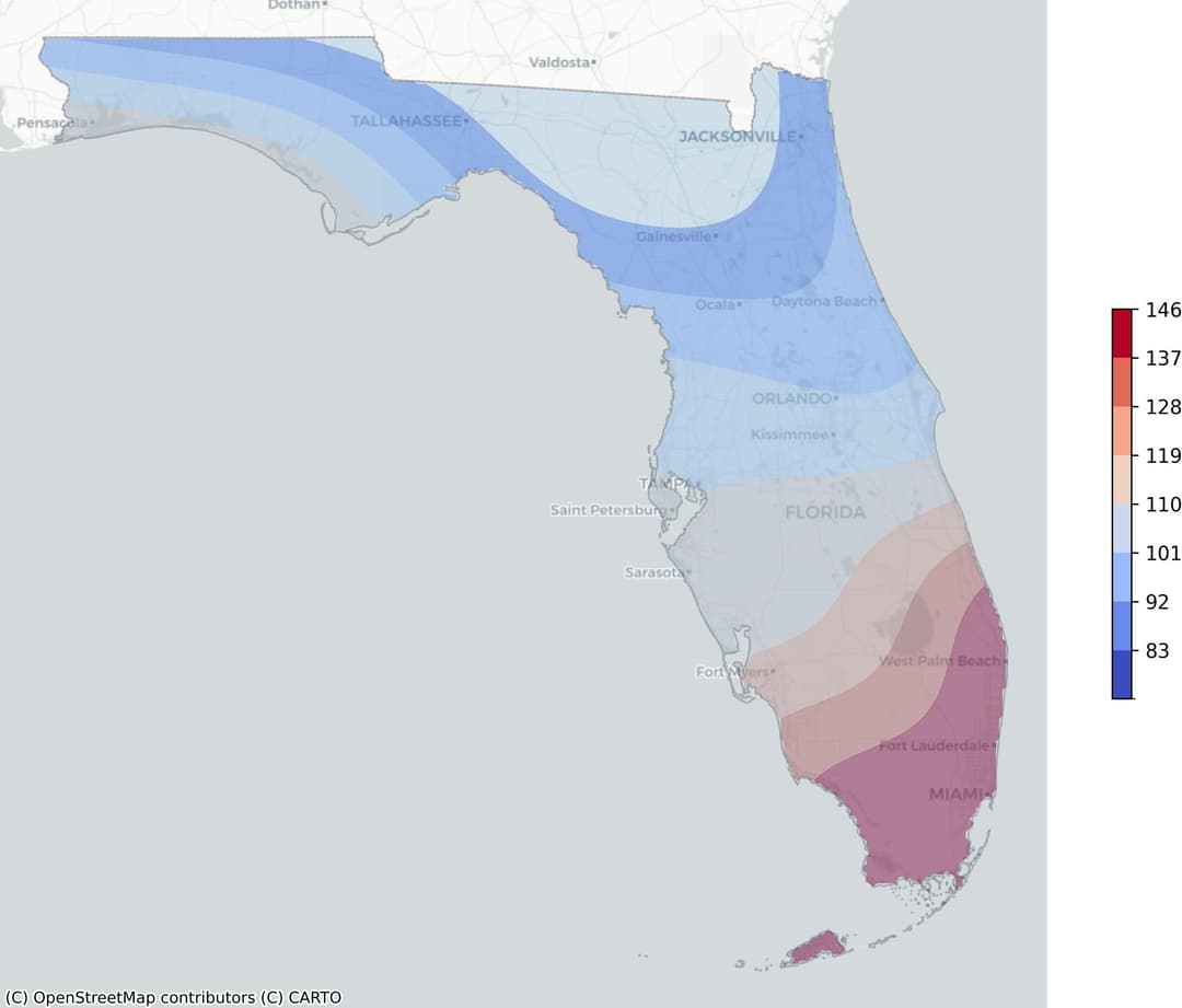
The following graph provides a visual representation of hurricane-prone areas in Florida. The heatmap, defined by the frequency of occurrence weighted by wind speed, transitions from blue to red. Blue areas indicate lower-risk regions, while red areas represent the highest risk.

The dense red clusters on the graph represent Southeast Florida and the Florida Keys, emphasizing their vulnerability to hurricanes. The Tampa Bay area, while not as intensely red, still exhibits a significant risk level due to the presence of lighter red and orange hues.
What Are The Recent Hurricanes in Florida?
- Hurricane Ian (2022): The most recent and third-costliest United States hurricane on record, Ian caused an estimated $112.9 billion worth of total damage, with $109.5 billion in Florida alone. The catastrophic storm surge and wind left a huge swath of damage, primarily in southwestern Florida. It also led to the loss of several lives, including five in Florida.
- Hurricane Irma (2017): Irma caused around $50.0 billion worth of damage, making it the fifth-costliest hurricane to affect the United States. Seven direct deaths were reported in Florida due to the hurricane, with 80 indirect deaths mainly due to falls, vehicle accidents, carbon monoxide poisoning from generators, and electrocutions. The damage was most severe in the Florida Keys.
- Hurricane Michael (2018): Michael directly caused 16 deaths: seven in Florida, five in Virginia, three in North Carolina, and one in Georgia. It left a swath of destruction in its wake, with the most significant damage in Bay County, Florida, particularly in Mexico Beach.
- Hurricane Hermine (2016): Hermine resulted in wind and water damage totaling around $550 million. The damage primarily occurred due to storm surges and high winds in Franklin, Wakulla, Taylor, Dixie, and Levy Counties in Florida. The hurricane also led to widespread power outages.
- Hurricane Matthew (2016): Matthew caused a loss of life and specific damage in Florida, with two direct fatalities and nine indirect deaths reported. More than 1.2 million customers lost electrical power across the state due to the hurricane.
- Hurricane Jeanne (2004): Jeanne resulted in a total U.S. damage estimate of 6.88 billion dollars and 23 direct deaths, including three in Florida. The hurricane produced ten tornadoes over the Florida peninsula, causing widespread damage.
- Hurricane Charley (2004): Charley resulted in several deaths, including one in Lee County and one in Sarasota County, Florida. The hurricane also indirectly caused an additional 25 U.S. deaths.
How to Prepare for A Hurricane Season in Florida
Preparing for a hurricane season in Florida is a critical aspect of disaster management. Being prepared can significantly reduce the potential risks and damages associated with hurricanes. Before a Hurricane
The following is a brief hurricane preparation checklist:
- Identify a Safe Room: Choose a small, windowless, interior room on the lowest level of your home. This room will serve as a shelter during the hurricane.
- Prepare an Emergency Kit: This should include water, non-perishable food, medications, important documents, flashlights, batteries, and other essentials.
- Secure Your Home: Cover windows with storm shutters or plywood. Secure outdoor items that could be swept away or damaged.
- Check Insurance Coverage: Ensure that your insurance covers hurricane preparedness and damages.
- Know Your Evacuation Route: Familiarize yourself with the local evacuation route and have a plan in place in case you need to leave your home.
- Stay Informed: Monitor local weather reports and heed any warnings or instructions from local officials.
During a Hurricane
To ensure safety during a hurricane, consider following these essential steps:
- Stay informed about the hurricane's path. Monitor the news, radio broadcasts, or official weather websites for updates.
- Avoid areas that are prone to flooding. Fast-rising water can be a significant threat during a hurricane.
- Remain indoors, preferably in a room without windows. The high winds associated with hurricanes can turn loose objects into dangerous projectiles.
- Follow evacuation orders promptly. If local authorities instruct you to evacuate, do so without delay.
- Have a disaster supplies kit ready. This should include necessities like food, water, medications, and important documents.
After a Hurricane
The aftermath of a hurricane can be as devastating as the storm itself. Knowing what to do next is crucial. Here's a list of steps to consider, particularly for those living in areas like Florida where such natural disasters are more common:
Step 1: Ensure Safety - Confirm everyone's safety and avoid venturing outside until local authorities have declared it safe. Beware of hazards like downed power lines and contaminated water.
Step 2: Document Damage - Take photos or videos to document the extent of damage to your property. This can be useful for insurance claims.
Step 3: Contact Insurance Company - Report the damage to your insurance company as soon as possible. Keep a record of all conversations and correspondences.
Step 4: Apply for Assistance - If eligible, apply for disaster assistance from the Federal Emergency Management Agency (FEMA). You can apply online, over the phone, or by mail.
Step 5: Start Clean-up - Begin the clean-up process once it's safe. Wear protective gear and watch out for wildlife displaced by the storm.